Atlantis
Real Ancient North American History
The pre-European history of America and Canada has a lot of anomalous evidence in contrast to the history that’s been taught in the history books throughout the centuries. The subject is soo large that all this specific MainframeX.com record is indented to do is start the documentation of these disparities between the anomalous evidence and what has been taught in the history books since Europeans arrived and colonized the land.
There are prevailing preconceived notions that the indigenous peoples of America and Canada were primitive, uncivilized, nomadic, had no written language and didn’t have any of the advanced knowledge and technologies the Europeans had. Evidence has been turning up since the beginning of European arrival that has been in stark contradiction to all these notions and assumed facts.
What the majority of history books (taught in schools) have failed to mentioned is that indigenous peoples of the Americas had:
1) over 200,000 well organized and advanced structured cities and mounds throughout the continent (ex. mount builders of Missouri, city of Monks Mound in Cahokia, and many more)
2) well established trade routes, some of which were very long
3) knowledge and technology to smelt metal and fashion metal objects (ex. numerous pre-Columbian metal objects have been found, Mississippian culture copper artifacts)
4) written language
5) numerous giant earthworks throughout the continent that would require immense organization of workers and architectural skills
In addition to this, there are numerous mysterious large dolmens located throughout the Americas and structures that some have suggested are megalithic that would require advanced technologies to erect and lift enormous stones.
Also, diffusionists believe there is compelling evidence suggesting that some of indigenous peoples of America were descendants of ancient Semitic people, with some evidence suggesting a link to the Phoenicians, who are themselves linked to the ancient Assyrian Empire. This evidence consists of numerous objects found with an ancient version of Hebrew written on them, and the fact the many indigenous people have DNA from haplogroup X, where the other primary source of this haplotype originates in the Middle East.
Again this barely scratches the surface of all the evidence that exists.
There is also evidence suggesting in the 1900s that political, bias and racist beliefs drove very early archeological sciences in the Americas to skew and suppress the actual history of indigenous people.

(An artist’s rendition of Cahokia Mounds in 1150 AD. Photo credit: Cahokia Mounds Museum Society and Art Grossman)

(Monks Mound in Cahokia. Image owner: https://commons.wikimedia.org/wiki/File:Monks_Mound_in_July.JPG)
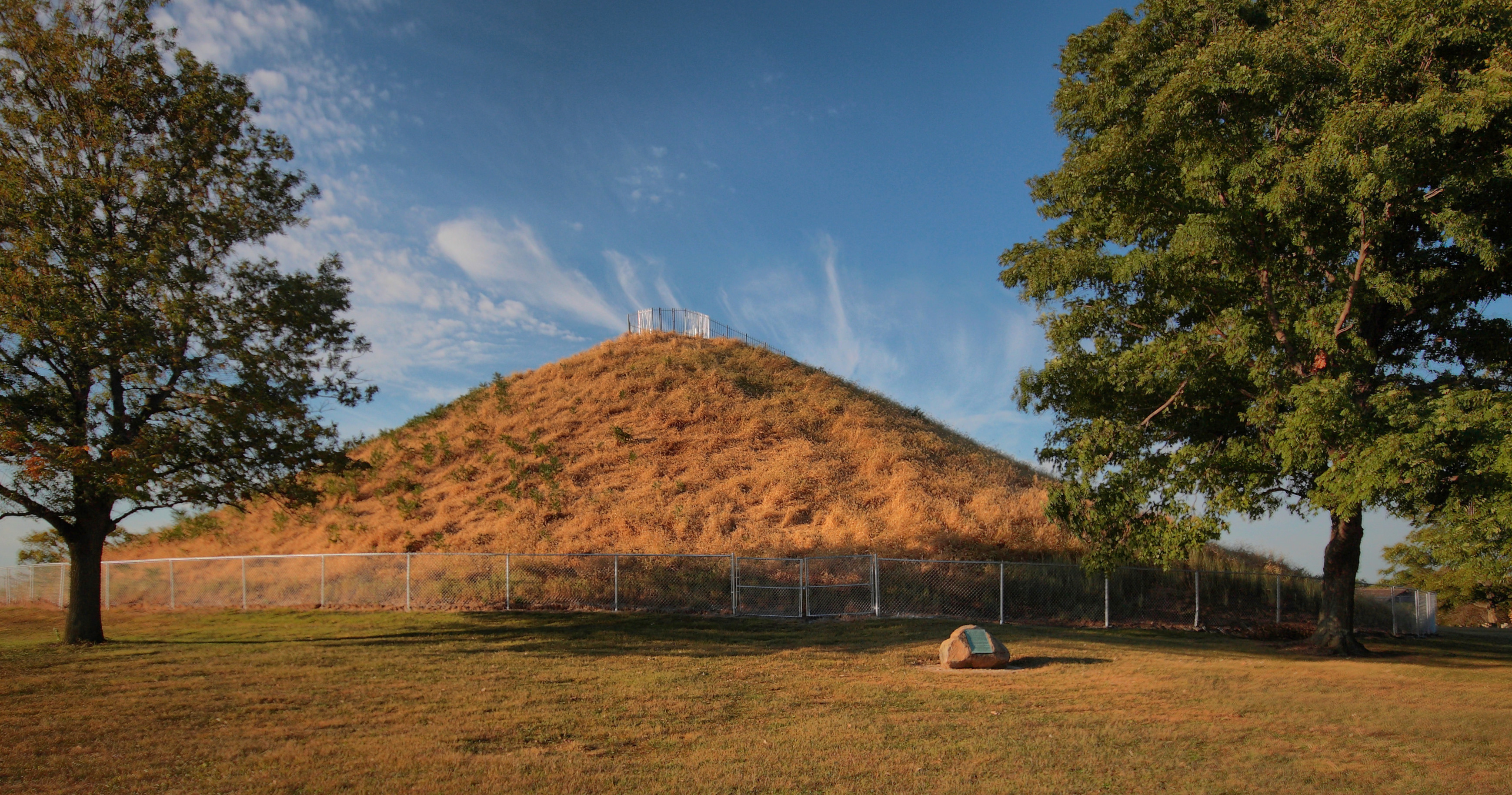
(Miamisburg Mound in Miamisburg, Ohio. Image owner: https://commons.wikimedia.org/wiki/File:MoundElevation.jpg)
The following video found on YouTube goes into excellent detail of the disparities and anomalous evidence that exists of ancient pre-Columbian American history.
(The Lost Civilizations of North America Documentary Trailer: http://www.lostcivilizationdvd.com/documentary.html)
Reference:
https://en.wikipedia.org/wiki/Cahokia
https://www.ohiohistory.org/visit/museum-and-site-locator/miamisburg-mound
http://www.lostcivilizationdvd.com/
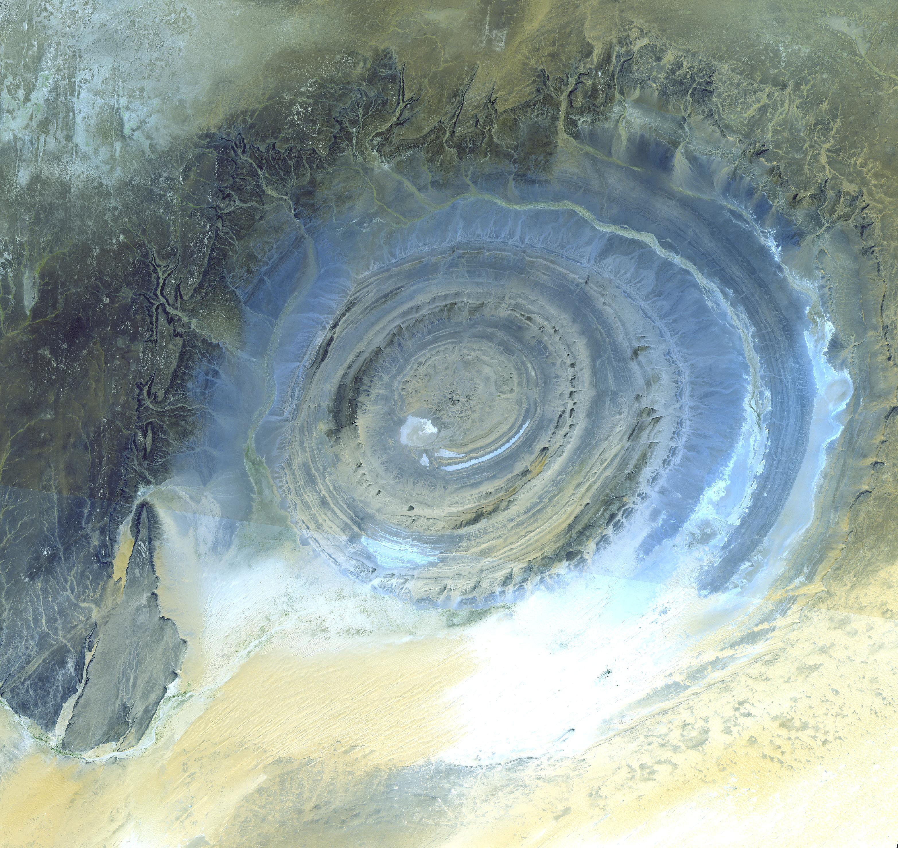
The Mysterious Richat Structure (Atlantis?)
Initially this structure in Mauritania was thought to be an impact structure. It is now believed to be an eroded salt dome, but how it was formed is inconclusive. It is 50 km in diameter (23.5 km largest inner ring), about the size of modern city.
Besides this structure’s mysterious geological origins, it has been proposed by some that this structure closely resembles Plato’s ancient description of Altantis with its large concentric circular rings, and it really does match Plato’s description of Atlantis. It is also located in a region in Mauritania south west of the Pillars of Hercules (Strait of Gibraltar) below the Atlas Mountain range (“Atlantis” mountain range?).
It has been proposed by some researchers that Atlantis existed in the Antediluvian era, in a time before the Great Flood and the prehistoric ancient world’s destruction, and that it was destroyed by the Great Flood in a giant tsunami. It is also possible that parts of the ancient Sahara Desert were ocean. The structure itself does contain salt implying a dried up ancient sea. Perhaps the Mediterranean Sea spilled into the Sahara Desert during or prior to the last ice age, and that water subsequently spilled into the Atlantic ocean. Or it’s possible the land elevations in the past were very different than they are today. There also appears to be on main “channel” or “canal” leading away from the structure, which matches Plato’s description also.
One research has suggested that if this isn’t Atlantis itself, that it is perhaps an ancient city belonging to Poseidon’s ancient empire collectively called Atlantis, which later changed phonologically to “Atlantic”, where Poseidon was a king, not a god.
(Image owner: https://commons.wikimedia.org/wiki/File:ASTER_Richat.jpg)
The following is the only free movie linking the Richat Structure to Atlantis:
References
http://www.gpofr.com/documents/2012Atlantis.pdf (broken link 2014)
Captured: 2012-Atlantis.pdf
https://en.wikipedia.org/wiki/Richat_Structure
Anomalous Underwater Pattern in the Atlantic (Atlantis?)
There was an anomalous underwater pattern in the Atlantic discovered on Google Earth by various sources that was about 50 km x 50 km. The images are reportedly collected by government resources and given to Google for their Google Earth and Google Maps products. The grid pattern of this image looks like a very large, somewhat symmetrical, city. Some have linked this to a possible site for Atlantis since it’s located in the Atlantic and outside the Pillars of Hercules (Strait of Gibraltar).
Skeptics believe that this anomalous pattern is nothing more than ship tracks, but aspects of the lines in the pattern do not meet the criteria for ship tracks.
Ultimately what this anomaly really is is unknown.
The FarSight video here goes into the hypothetical of what this pattern might actually be. Given the lack of underwater exploration of this sight, this is perhaps the best anyone can surmise if indeed these lines are not ship tracks.
References
http://www.gpofr.com/documents/2012Atlantis.pdf (broken link 2014)