Geological Anomaly
The Mysterious Richat Structure (Atlantis?)
Initially this structure in Mauritania was thought to be an impact structure. It is now believed to be an eroded salt dome, but how it was formed is inconclusive. It is 50 km in diameter (23.5 km largest inner ring), about the size of modern city.
Besides this structure’s mysterious geological origins, it has been proposed by some that this structure closely resembles Plato’s ancient description of Altantis with its large concentric circular rings, and it really does match Plato’s description of Atlantis. It is also located in a region in Mauritania south west of the Pillars of Hercules (Strait of Gibraltar) below the Atlas Mountain range (“Atlantis” mountain range?).
It has been proposed by some researchers that Atlantis existed in the Antediluvian era, in a time before the Great Flood and the prehistoric ancient world’s destruction, and that it was destroyed by the Great Flood in a giant tsunami. It is also possible that parts of the ancient Sahara Desert were ocean. The structure itself does contain salt implying a dried up ancient sea. Perhaps the Mediterranean Sea spilled into the Sahara Desert during or prior to the last ice age, and that water subsequently spilled into the Atlantic ocean. Or it’s possible the land elevations in the past were very different than they are today. There also appears to be on main “channel” or “canal” leading away from the structure, which matches Plato’s description also.
One research has suggested that if this isn’t Atlantis itself, that it is perhaps an ancient city belonging to Poseidon’s ancient empire collectively called Atlantis, which later changed phonologically to “Atlantic”, where Poseidon was a king, not a god.
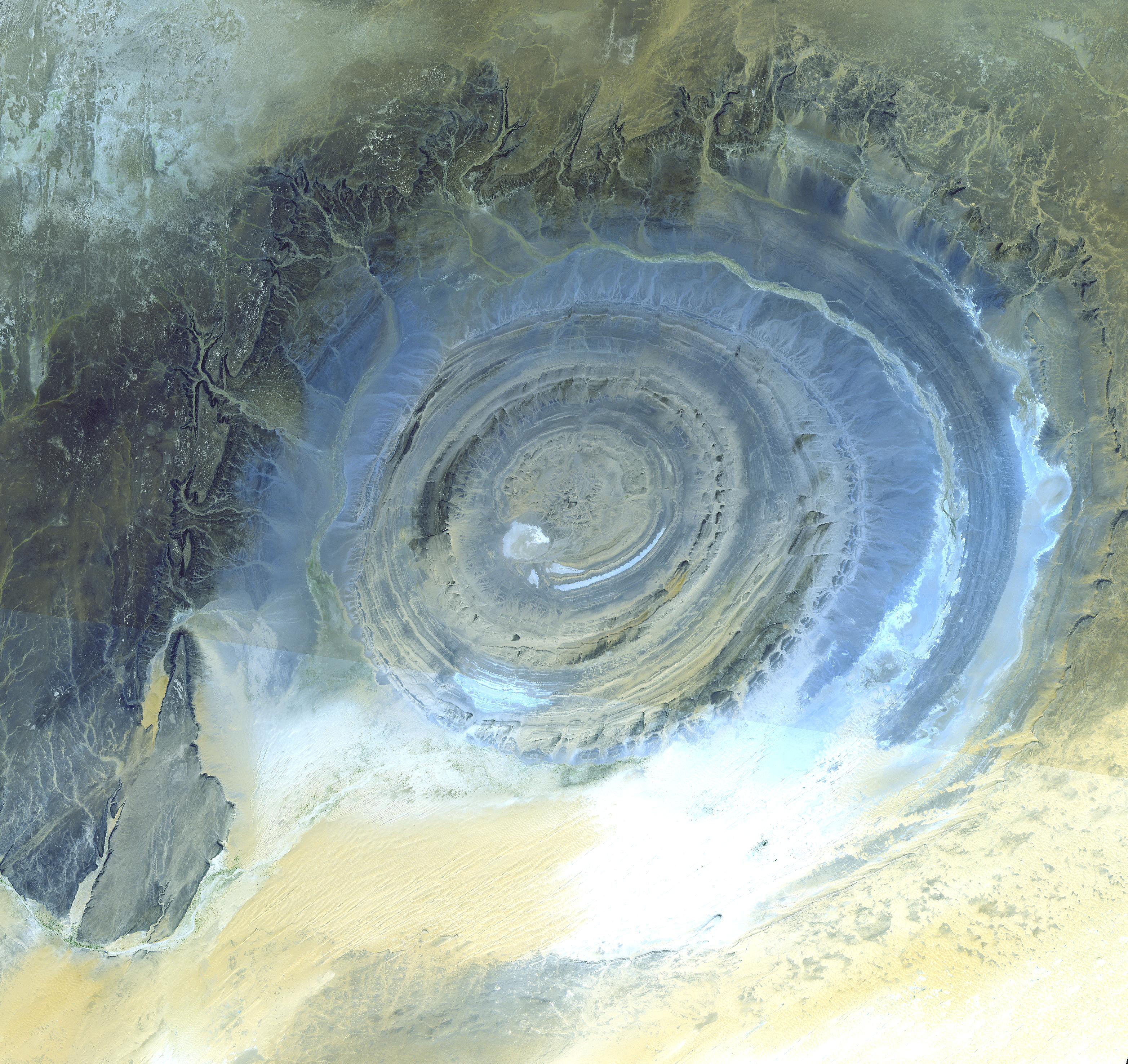
(Image owner: https://commons.wikimedia.org/wiki/File:ASTER_Richat.jpg)
The following is the only free movie linking the Richat Structure to Atlantis:
References
http://www.gpofr.com/documents/2012Atlantis.pdf (broken link 2014)
Captured: 2012-Atlantis.pdf
https://en.wikipedia.org/wiki/Richat_Structure
Anomalous Underwater Pattern in the Atlantic (Atlantis?)
There was an anomalous underwater pattern in the Atlantic discovered on Google Earth by various sources that was about 50 km x 50 km. The images are reportedly collected by government resources and given to Google for their Google Earth and Google Maps products. The grid pattern of this image looks like a very large, somewhat symmetrical, city. Some have linked this to a possible site for Atlantis since it’s located in the Atlantic and outside the Pillars of Hercules (Strait of Gibraltar).
Skeptics believe that this anomalous pattern is nothing more than ship tracks, but aspects of the lines in the pattern do not meet the criteria for ship tracks.
Ultimately what this anomaly really is is unknown.
The FarSight video here goes into the hypothetical of what this pattern might actually be. Given the lack of underwater exploration of this sight, this is perhaps the best anyone can surmise if indeed these lines are not ship tracks.
References
http://www.gpofr.com/documents/2012Atlantis.pdf (broken link 2014)
Ancient Canals (North America)
John Jensen some years ago called into question the origin of canals carved into the landscape of the Louisiana coast, and other areas along the American side the Gulf of Mexico.
The evidence collected of many of these canals do not match up with any known historical source, and appear to link to a time prior to European colonization of North America.
https://www.google.ca/maps/@29.7463636,-89.7055309,1489m/data=!3m1!1e3
His work can be found here:
http://www.academia.edu/3779666/Ancient_Canal_Builders_-_Overview
His online blog:
http://earthepochs.blogspot.ca/
John Jensen interview: